Coupled with the latest drones, our pilots use mapping software to investigate accidents without wasting time or resources deploying manned helicopters. In many cases, a traffic accident scene scan takes less than 10 minutes with a drone.
Once imagery is captured from the scene, it’s processed into high-resolution maps and 3D models for further inspection.
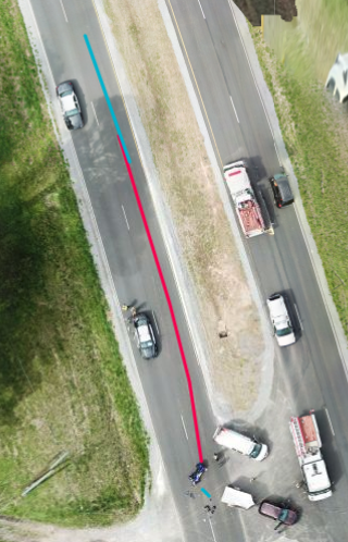
Using UAS-AERIAL SOLUTIONS, you can then mark-up the scene with notes, measurements, and annotations.
“The ability to take measurements in the software is a big benefit,” said Sergeant Roberts. “It generates comparable results to our officer’s existing methods.” And because DroneDeploy captures the entire scene in 3D, investigators can permanently archive the digital reconstruction. It’s also easy to share maps and 3D models with collaborators back in the office because DroneDeploy is cloud-based.